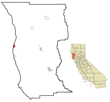
फर्ट ब्र्याग, क्यालिफोर्निया
Appearance
| City of Fort Bragg | |
|---|---|
| — City — | |
 |
|
 |
|
| Coordinates: 39°26′45″N 123°48′19″W / 39.44583°N 123.80528°WCoordinates: 39°26′45″N 123°48′19″W / 39.44583°N 123.80528°W | |
| Area | |
| - Total | ७.२ km2 (२.८ sq mi) |
| - Land | ७.१ km2 (२.७ sq mi) |
| - Water | ०.१ km2 (०.० sq mi) |
| Elevation[१] | २६ m (८५ ft) |
| Population (2000) | |
| - Total | ७,०२६ |
| - Density | ९९३.७/km2 (२,५७३.७/sq mi) |
| Time zone | PST (UTC-8) |
| - Summer (DST) | PDT (UTC-7) |
| ZIP codes | 95437, 95488 |
| Area code(s) | 707 |
| FIPS code | 06-25058 |
| GNIS feature ID | 1656027 |
| Website | http://ci.fort-bragg.ca.us/ |
फर्ट ब्र्याग संयुक्त राज्य अमेरिकायागु क्यालिफोर्निया राज्ययागु छगु सिटी खः।
जनसंख्या
[सम्पादन]सन् २०००यागु तथ्यांक कथलं थ्व थाय्यागु जनसंख्या ७०२६ दु धासा थ्व थासे ३०५१ खा छें दु[२]।
भूगोल
[सम्पादन]थ्व शहरयागु अक्षांश ३९.४४२१५५ उत्तर व देशान्तर १२३.८०२४६३ पश्चिम खः ()। थ्व थासे ७०६१०९२ वर्ग मिटर (२.७२६३०३ वर्ग माइल) जमिन दु धासा १११६९४ वर्ग मिटर (०.०४३१२५ वर्ग माइल) ल दु[२]।
लिधंसा
[सम्पादन]- ↑ U.S. Geological Survey Geographic Names Information System: फर्ट ब्र्याग, क्यालिफोर्निया
- ↑ २.० २.१ अमेरिकी जनगणना २००१. जुन ९, ई सं २००७ कथं।
| विकिमिडिया मंका य् थ्व विषय नाप स्वापु दुगु मिडिया दु: Fort Bragg, California |
