तिग्रिस खुसि
Appearance
| तिग्रिस खुसि | |
| River | |
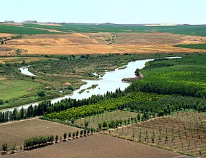
About 100 km from its source, the Tigris enables rich agriculture outside Diyarbakır, Turkey.
| |
| Countries | तर्कि, सिरिया, इराक |
|---|---|
| बेसिन ख्यः | तर्कि, सिरिया, इराक, इरान |
| Tributaries | |
| - left | Batman, Khabur, Greater Zab, Lesser Zab, 'Adhaim, Diyala, Cizre |
| - right | Wadi Tharthar |
| Cities | Diyarbakır, Mosul, Baghdad |
| Source | Lake Hazar |
| - elevation | १,१५० m (३,७७३ ft) |
| - coordinates | 38°29′0″N 39°25′0″E / 38.48333°N 39.41667°E |
| Mouth | Shatt al-Arab |
| - location | Al-Qurnah, Basra Governorate, Iraq |
| Length | १,८५० km (१,१५० mi) |
| Basin | ३७५,००० km² (१४४,७८८ sq mi) |
| Discharge | for Baghdad |
| - average | १,०१४ m³/s (३५,८०९ cu ft/s) |
| - max | २,७७९ m³/s (९८,१३९ cu ft/s) |
| - min | ३३७ m³/s (११,९०१ cu ft/s) |
| [१][२] | |
तिग्रिस खुसि मध्यपूर्वया छगू मू खुसि ख। थ्व खुसिया सिथय् दकलय् न्हापांगु मनुया लहनाय् छगू पलिस्था जूगुलिं थुकियात लहनाया क्रेदल नं धाइगु या।
लिधंसा
[सम्पादन]- ↑ (2009) "The hydrology, evolution, and hydrological regime of the mouth area of the Shatt al-Arab River". Water Resources 36 (4): 380–395. DOI:10.1134/S0097807809040022.
- ↑ (1991) The Euphrates River and the Southeast Anatolia Development Project. Carbondale: Southern Illinois University Press, 6–8.
स्वयादिसँ
[सम्पादन]| विकिमिडिया मंका य् थ्व विषय नाप स्वापु दुगु मिडिया दु: Tigris |


