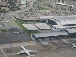
Tan Son Nhat International Airport
Appearance
| थ्व च्वसुयात नेपालभाषाय् अनुवाद याये मानि। थ्व च्वसुइत नेपालभाषाय् अनुवाद याना ग्वहालि यानादिसँ। |
| Tan Son Nhat International Airport Sân bay Quốc tế Tân Sơn Nhất | |||
|---|---|---|---|

| |||
| IATA: SGN – ICAO: VVTS | |||
| Summary | |||
| Airport type | Public | ||
| Owner | Vietnamese government | ||
| Operator | Southern Airports Corporation | ||
| Serves | Ho Chi Minh City, Vietnam | ||
| Location | Tan Binh District | ||
| Hub for | Indochina Airlines Jetstar Pacific Airlines Vietnam Airlines | ||
| Elevation AMSL | 10 m / 33 ft | ||
| Coordinates | 10°49′08″N 106°39′07″E / 10.81889°N 106.65194°E | ||
| Website | |||
| Runways | |||
| Direction | Length | Surface | |
| m | ft | ||
| 07L/25R | 3,048 | 10,000 | Concrete |
| 07R/25L | 3,800 | 12,468 | Concrete |
| Statistics (2008) | |||
| Passenger movements | 12.427.808 [१] | ||
| Airfreight movements in tonnes | 444.223 [१] | ||
| Aircraft movements | 98.002 [१] | ||

Tan Son Nhat International Airport is the largest airport in Vietnam. It’s 6 km from downtown Ho Chi Minh City. It was an important airbase of the United States during Vietnam War. In 2009, this airport served 13 million passengers. This airport receives 70% international passengers in Vietnamese airport.
| विकिमिडिया मंका य् थ्व विषय नाप स्वापु दुगु मिडिया दु: Tan Son Nhat International Airport |
