
किपा:WorldEmpires.png
Size of this preview: ८०० × ४८० pixels. Other resolutions: ३२० × १९२ pixels | १,०२४ × ६१४ pixels | १,२८० × ७६८ pixels | ३,००० × १,८०० pixels.
Original file (३,००० × १,८०० pixels, file size: ५६१ KB, MIME type: image/png)
Summary
| Description |
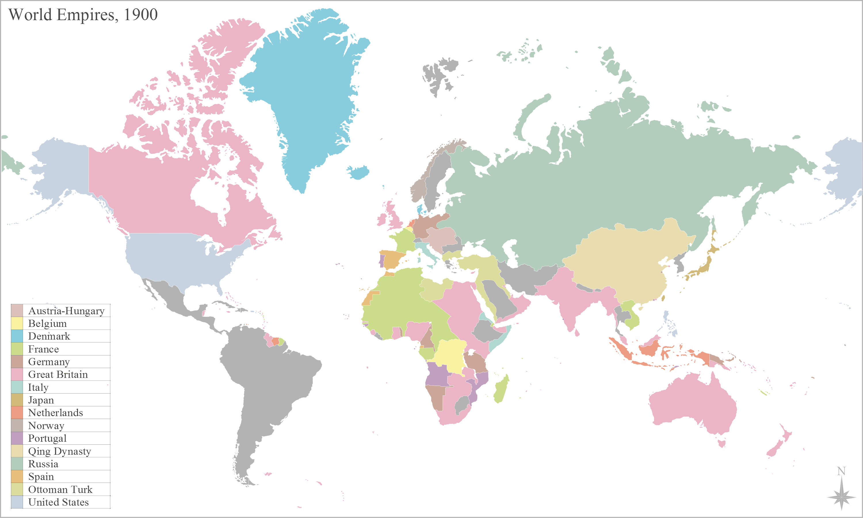
English: Map of the worlds empires, during 1900 |
| Date | |
| Source | Own work |
| Author | George Bosanko |
Licensing
I, the copyright holder of this work, hereby publish it under the following license:
This file is licensed under the Creative Commons Attribution-Share Alike 3.0 Unported license.
- You are free:
- to share – to copy, distribute and transmit the work
- to remix – to adapt the work
- Under the following conditions:
- attribution – You must give appropriate credit, provide a link to the license, and indicate if changes were made. You may do so in any reasonable manner, but not in any way that suggests the licensor endorses you or your use.
- share alike – If you remix, transform, or build upon the material, you must distribute your contributions under the same or compatible license as the original.
File history
Click on a date/time to view the file as it appeared at that time.
| Date/Time | Thumbnail | Dimensions | छ्य्लामि | Comment | |
|---|---|---|---|---|---|
| current | १२:२१, २९ ज्यानुवरी २०१४ | | ३,००० × १,८०० (५६१ KB) | Alphathon | Reverted to version as of 16:17, 2 June 2012. Numerous errors introduced (e.g. Nicaragua part of US, Ottoman Empire renamed Turkey) and some changes which don't apply accross whole (newly intorduced) time span (e.g. Italian Libya, non-Ottoman Balkans) |
| ०२:२५, १८ अगस्ट २०१३ |  | ३,००० × १,८०० (६७४ KB) | Mttll | Fixed legend | |
| १६:१७, २ जुन २०१२ |  | ३,००० × १,८०० (५६१ KB) | GBozanko | Change date and fixes to coincide with that; Added Qing Dynasty; removal of Transvaal and Orange Free State from British South Africa; addition of Ottoman European Territories; removal of US administration of Nicaragua; fix of British Nigeria and Germa... | |
| १५:२४, २६ मे २०१२ |  | ३,००० × १,८०० (५५९ KB) | Geord0 | Harmonious with 'British Somaliland 1884–1960' article, and sourced map from the United Kingdom National Archive 'maps in time' http://www.nationalarchives.gov.uk/cabinetpapers/themes/maps-interactive/maps-in-time.htm | |
| १४:३५, २६ मे २०१२ |  | ८०१ × ४८० (१११ KB) | Runehelmet | British Somaliland and North Western part of Italian Somaliland were under control of the Dervish State in the given timeline. | |
| १५:३०, १९ मे २०१२ |  | ३,००० × १,८०० (५५९ KB) | Geord0 |
File usage
The following page uses this file:
Global file usage
The following other wikis use this file:
- Usage on af.wikipedia.org
- Usage on ar.wikipedia.org
- إمبراطورية
- بوابة:الإمبراطورية الروسية
- بوابة:الإمبراطورية الروسية/بوابات شقيقة
- بوابة:الإمبراطورية الألمانية
- بوابة:الإمبراطورية الألمانية/بوابات شقيقة
- بوابة:إمبراطورية اليابان
- بوابة:إمبراطورية اليابان/بوابات شقيقة
- بوابة:الخلافة الراشدة
- بوابة:الدولة الأموية
- بوابة:الإمبراطورية الفرنسية الأولى/بوابات شقيقة
- بوابة:الإمبراطورية الفرنسية الأولى
- بوابة:الإمبراطورية النمساوية/بوابات شقيقة
- بوابة:الإمبراطورية النمساوية
- بوابة:الإمبراطورية البريطانية
- بوابة:الإمبراطورية البريطانية/بوابات شقيقة
- بوابة:الإمبراطورية الفرنسية الثانية
- بوابة:الإمبراطورية الفرنسية الثانية/بوابات شقيقة
- بوابة:الإمبراطورية البرتغالية
- بوابة:الإمبراطورية البرتغالية/بوابات شقيقة
- بوابة:الإمبراطورية النمساوية المجرية
- بوابة:الإمبراطورية النمساوية المجرية/بوابات شقيقة
- بوابة:الإمبراطورية المغولية
- بوابة:الإمبراطورية المغولية/بوابات شقيقة
- بوابة:الإمبراطورية الإسبانية
- بوابة:إمبراطوريات
- بوابة:إمبراطوريات/واجهة
- بوابة:إمبراطوريات/بوابات شقيقة
- بوابة:الإمبراطورية الإسبانية/بوابات شقيقة
- بوابة:الدولة الأموية/بوابات شقيقة
- بوابة:الخلافة الراشدة/بوابات شقيقة
- بوابة:مملكة فرنسا
- بوابة:مملكة فرنسا/بوابات شقيقة
- بوابة:الإمبراطورية الرومانية المقدسة
- بوابة:الإمبراطورية الرومانية المقدسة/بوابات شقيقة
- قالب:بوابات الإمبراطوريات
- Usage on azb.wikipedia.org
- Usage on ca.wikipedia.org
- Usage on en.wikipedia.org
- Usage on es.wikipedia.org
- Usage on gom.wikipedia.org
- Usage on hy.wikipedia.org
View more global usage of this file.