
किपा:Punjab district map.png

Size of this preview: ५४० × ६०० pixels. Other resolutions: २१६ × २४० pixels | ४३२ × ४८० pixels | ६९१ × ७६८ pixels | ९२२ × १,०२४ pixels | २,४६७ × २,७४१ pixels.
Original file (२,४६७ × २,७४१ pixels, file size: ६३५ KB, MIME type: image/png)

|
This locator map image could be re-created using vector graphics as an SVG file. This has several advantages; see Commons:Media for cleanup for more information. If an SVG form of this image is available, please upload it and afterwards replace this template with
{{vector version available|new image name}}.
It is recommended to name the SVG file “Punjab district map.svg”—then the template Vector version available (or Vva) does not need the new image name parameter. |
Summary
| Description |
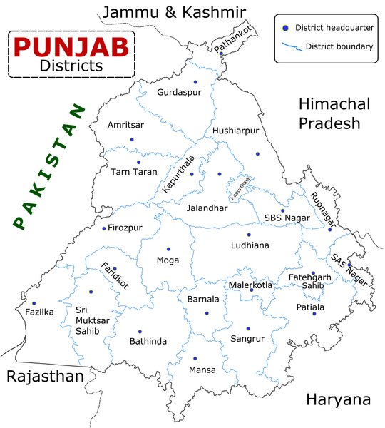
English: State of Punjab (Indian Punjab) with districts marked along with district Headquarters. |
| Date | |
| Source | Self made using Inkscape. Source map referred from Punjab govt. site. |
| Author | Wikigringo |
Licensing
I, the copyright holder of this work, hereby publish it under the following licenses:

|
Permission is granted to copy, distribute and/or modify this document under the terms of the GNU Free Documentation License, Version 1.2 or any later version published by the Free Software Foundation; with no Invariant Sections, no Front-Cover Texts, and no Back-Cover Texts. A copy of the license is included in the section entitled GNU Free Documentation License. |
This file is licensed under the Creative Commons Attribution-Share Alike 4.0 International, 3.0 Unported, 2.5 Generic, 2.0 Generic and 1.0 Generic license.
- You are free:
- to share – to copy, distribute and transmit the work
- to remix – to adapt the work
- Under the following conditions:
- attribution – You must give appropriate credit, provide a link to the license, and indicate if changes were made. You may do so in any reasonable manner, but not in any way that suggests the licensor endorses you or your use.
- share alike – If you remix, transform, or build upon the material, you must distribute your contributions under the same or compatible license as the original.
You may select the license of your choice.
File history
Click on a date/time to view the file as it appeared at that time.
| Date/Time | Thumbnail | Dimensions | छ्य्लामि | Comment | |
|---|---|---|---|---|---|
| current | ०९:२५, १० ज्यानुवरी २०२३ | | २,४६७ × २,७४१ (६३५ KB) | Saad Ali Khan Pakistan | updated district MalerKotla on map |
| ०४:४५, ७ जुलाई २०२० |  | २,४६७ × २,७४१ (८६७ KB) | Kaushal Bishnoi | New Update version of Punjab District Map with 22 District. | |
| १४:४१, ५ अक्टोबर २०१३ |  | १,०९४ × ८४८ (१२७ KB) | Ras67 | cropped and optimized | |
| ०८:४०, २८ अप्रिल २००८ |  | १,२११ × ८७४ (१८७ KB) | Wikigringo | Uploading a better color version of the file with bigger font size. | |
| १६:०१, २६ अप्रिल २००८ |  | १,२६९ × ९०७ (१६७ KB) | Wikigringo | {{Information |Description=State of Punjab, India with districts marked along with district HQ. |Source=Self made using Inkscape. Source map referred from Punjab govt. site. |Date=04/26/2008 |Author=Wikigringo |Permission= |other_versions= }} |
File usage
The following page uses this file:
Global file usage
The following other wikis use this file:
- Usage on ar.wikipedia.org
- Usage on azb.wikipedia.org
- Usage on bh.wikipedia.org
- Usage on bn.wikipedia.org
- Usage on ca.wikipedia.org
- Usage on ceb.wikipedia.org
- Usage on en.wikipedia.org
- Usage on es.wikipedia.org
- Usage on eu.wikipedia.org
- Usage on fa.wikipedia.org
- Usage on fi.wikipedia.org
- Usage on fr.wikipedia.org
- Pendjab (Inde)
- District de Barnala
- District de Faridkot
- District de Fatehgarh Sahib
- District de Fazilka
- District de Firozpur
- District de Gurdaspur
- District de Hoshiarpur
- District de Jalandhar
- District de Kapurthala
- District de Ludhiana
- District de Mansa (Penjab)
- District de Moga
- District de Mohali
- District de Muktsar
View more global usage of this file.