
किपा:Colorado.png
Size of this preview: ७७९ × ६०० pixels. Other resolutions: ३१२ × २४० pixels | ६२३ × ४८० pixels | ९९७ × ७६८ pixels | १,०६६ × ८२१ pixels.
Original file (१,०६६ × ८२१ pixels, file size: ४२६ KB, MIME type: image/png)
Summary
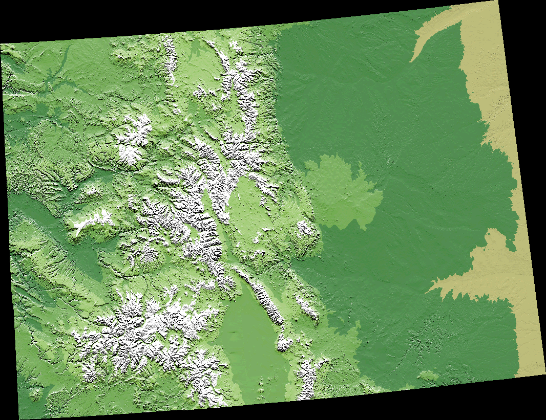
A digital elevation model (DEM) map of Colorado.
The map is from [1] archive copy at the Wayback Machine, specifically Colorado.gif archive copy at the Wayback Machine.
Licensing
This image is in the public domain in the United States because it only contains materials that originally came from the United States Geological Survey, an agency of the United States Department of the Interior. For more information, see the official USGS copyright policy.
|
File history
Click on a date/time to view the file as it appeared at that time.
| Date/Time | Thumbnail | Dimensions | छ्य्लामि | Comment | |
|---|---|---|---|---|---|
| current | ००:०२, ११ सेप्टेम्बर २००५ | | १,०६६ × ८२१ (४२६ KB) | Dbenbenn | from http://wwwflag.wr.usgs.gov/USGSFlag/Data/maps/ColoradoDEM.html, PD |
File usage
More than १०० pages use this file. The following list shows the first १०० pages that use this file only. A full list is available.
- अगुलियार, कोलोर्याडो
- अरिबा, कोलोर्याडो
- अर्भादा, कोलोर्याडो
- आर्बोलेस, कोलोर्याडो
- इकली, कोलोर्याडो
- इगल, कोलोर्याडो
- इगल भेल, कोलोर्याडो
- इटन, कोलोर्याडो
- इड्स, कोलोर्याडो
- इस्ट प्लिजेन्ट भ्यू, कोलोर्याडो
- एअर फोर्स एकेडेमी, कोलोर्याडो
- एकर्स ग्रीन, कोलोर्याडो
- एक्रोन, कोलोर्याडो
- एज्वाटर, कोलोर्याडो
- एट्वूड, कोलोर्याडो
- एन्टोनियो, कोलोर्याडो
- एप्पलवूड, कोलोर्याडो
- एभोन, कोलोर्याडो
- एभोनडेल, कोलोर्याडो
- एरिस्टोक्र्याट र्र्यान्चेट्स, कोलोर्याडो
- एलामोजा, कोलोर्याडो
- एलामोजा इस्ट, कोलोर्याडो
- एलेनस्पार्क, कोलोर्याडो
- एल्मा, कोलोर्याडो
- एस्पेन, कोलोर्याडो
- एस्पेन पार्क, कोलोर्याडो
- औरोरा, कोलोर्याडो
- औल्ट, कोलोर्याडो
- कटनवूड, कोलोर्याडो
- कमर्स सिटी, कोलोर्याडो
- कर्टेज, कोलोर्याडो
- कल्ब्र्यान, कोलोर्याडो
- कार्बनडेल, कोलोर्याडो
- कोकडेल, कोलोर्याडो
- कोल क्रीक, कोलोर्याडो
- कोलम्बाइन, कोलोर्याडो
- कोलम्बाइन भ्याली, कोलोर्याडो
- कोलोर्र्याडो सिटी, कोलोर्याडो
- कोलोर्र्याडो स्प्रिङ्गस्, कोलोर्याडो
- क्यानन सिटी, कोलोर्याडो
- क्याम्पियन, कोलोर्याडो
- क्याम्पो, कोलोर्याडो
- क्यारिज क्लब, कोलोर्याडो
- क्याल्ह्यान, कोलोर्याडो
- क्यासल पाइन्स, कोलोर्याडो
- क्यासल रक, कोलोर्याडो
- क्यासलवूड, कोलोर्याडो
- क्यास्केडचिपिटा पार्क, कोलोर्याडो
- क्रफर्ड, कोलोर्याडो
- क्रिपल क्रीक, कोलोर्याडो
- क्रीड, कोलोर्याडो
- क्रूक, कोलोर्याडो
- क्रेग, कोलोर्याडो
- क्रेस्टेड बट, कोलोर्याडो
- क्रेस्टोन, कोलोर्याडो
- क्रोली, कोलोर्याडो
- क्लिफटन, कोलोर्याडो
- चेरा, कोलोर्याडो
- चेरी हिल्स भिलेज, कोलोर्याडो
- डर्बी, कोलोर्याडो
- डाउनी भिललासन ड्युमोन्ट, कोलोर्याडो
- डायनोसौर, कोलोर्याडो
- डिलन, कोलोर्याडो
- डुरांगो, कोलोर्याडो
- डे बेक, कोलोर्याडो
- डेल नर्टे, कोलोर्याडो
- डेल्टा, कोलोर्याडो
- डोभ क्रीक, कोलोर्याडो
- डोलोरेस, कोलोर्याडो
- ड्यर ट्रेल, कोलोर्याडो
- ड्याकोनो, कोलोर्याडो
- देन्भर
- बर्क्ली, कोलोर्याडो
- बर्थोड, कोलोर्याडो
- बर्लिङ्गटन, कोलोर्याडो
- बसाल्ट, कोलोर्याडो
- बाउल्डर, कोलोर्याडो
- बायर्स, कोलोर्याडो
- बून, कोलोर्याडो
- बेउलाः भ्याली, कोलोर्याडो
- बेथुएन, कोलोर्याडो
- बेनेट, कोलोर्याडो
- बेफिल्ड, कोलोर्याडो
- बो मार, कोलोर्याडो
- बोन्यांजा, कोलोर्याडो
- ब्याटलमेन्ट मेसा, कोलोर्याडो
- ब्युयना भिस्टा, कोलोर्याडो
- ब्रश, कोलोर्याडो
- ब्राइटन, कोलोर्याडो
- ब्रूकसाइड, कोलोर्याडो
- ब्रूमफिल्ड, कोलोर्याडो
- ब्रेकेनरिज, कोलोर्याडो
- ब्र्यान्सन, कोलोर्याडो
- ब्लांका, कोलोर्याडो
- ब्लु रिभर, कोलोर्याडो
- ब्ल्याक फरेस्ट, कोलोर्याडो
- ब्ल्याक हक, कोलोर्याडो
- शिने वेल्स, कोलोर्याडो
- सिमारन हिल्स, कोलोर्याडो
- सेडारेज, कोलोर्याडो
View more links to this file.
Global file usage
The following other wikis use this file:
- Usage on de.wikipedia.org
- Usage on en.wikipedia.org
- Usage on es.wikipedia.org
- Usage on fo.wikipedia.org
- Usage on fr.wikipedia.org
- Usage on he.wikipedia.org
- Usage on it.wikipedia.org
- Usage on ja.wikipedia.org
- Usage on la.wikipedia.org
- Usage on no.wikipedia.org
- Usage on vi.wikipedia.org