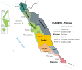
किपा:Bushehr - political.svg

Page contents not supported in other languages.
विकिपिडिया नं

Original file(SVG file, nominally १,४६३ × १,२५१ pixels, file size: २८८ KB)

This file is from Wikimedia Commons and may be used by other projects. The description on its file description page there is shown below.

Summary

Description
فارسی: نقشه سیاسی بوشهر به همراه جزایر مشهور آن
English: political map of Bushehr province with its islands plus zoomed-up sketch of the islands
Date
Source Own work - The data is adapted from here and everything about the license.
Author Rohalamin
Other versions
SVG genesis
InfoField
 
The SVG code is valid.
 
This map was created with Inkscape.
 
 This map uses embedded text that can be easily translated using a text editor.

Licensing

I, the copyright holder of this work, hereby publish it under the following license:
w:en:Creative Commons
attribution share alike
This file is licensed under the Creative Commons Attribution-Share Alike 4.0 International license.
You are free:
  • to share – to copy, distribute and transmit the work
  • to remix – to adapt the work
Under the following conditions:
  • attribution – You must give appropriate credit, provide a link to the license, and indicate if changes were made. You may do so in any reasonable manner, but not in any way that suggests the licensor endorses you or your use.
  • share alike – If you remix, transform, or build upon the material, you must distribute your contributions under the same or compatible license as the original.

Captions

Add a one-line explanation of what this file represents
Bushehr - political map

copyrighted English

inception English

५ नोभेम्बर 2021

media type English

image/svg+xml

checksum English

9b20a433cb89fa243148bead5b16d46d62769279

determination method English: SHA-1 English

data size English

२९४,७५९ byte

height English

१,२५१ pixel

width English

१,४६३ pixel

File history

Click on a date/time to view the file as it appeared at that time.

Date/TimeThumbnailDimensionsछ्य्‌लामिComment
current०६:३५, ११ फेब्रुवरी २०२२Thumbnail for version as of ०६:३५, ११ फेब्रुवरी २०२२१,४६३ × १,२५१ (२८८ KB)Rohalaminprovince word raplaced by county
१७:४१, ९ नोभेम्बर २०२१Thumbnail for version as of १७:४१, ९ नोभेम्बर २०२११,४६३ × १,२५१ (२८८ KB)Rohalaminposition of farsi island changed
११:११, ९ नोभेम्बर २०२१Thumbnail for version as of ११:११, ९ नोभेम्बर २०२११,४६३ × १,२५१ (२८८ KB)Rohalaminnew crop
११:०५, ९ नोभेम्बर २०२१Thumbnail for version as of ११:०५, ९ नोभेम्बर २०२११,४५३ × १,२५१ (२८८ KB)Rohalamincrop
०६:५५, ५ नोभेम्बर २०२१Thumbnail for version as of ०६:५५, ५ नोभेम्बर २०२१५१२ × ४५६ (२८० KB)RohalaminUploaded own work with UploadWizard

The following page uses this file:

Global file usage

The following other wikis use this file:

Metadata