किपा:Ancient Egypt map-en.svg
Page contents not supported in other languages.
विकिपिडिया नं

Original file(SVG file, nominally १,५७७ × ३,२१९ pixels, file size: ६८७ KB)

This file is from Wikimedia Commons and may be used by other projects. The description on its file description page there is shown below.

विकिपिडिया

 This is a featured picture on the English language Wikipedia (Featured pictures) and is considered one of the finest images. See its nomination here.

If you think this file should be featured on Wikimedia Commons as well, feel free to nominate it.
If you have an image of similar quality that can be published under a suitable copyright license, be sure to upload it, tag it, and nominate it.

Summary

 
This W3C-unspecified vector image was created with Inkscape .
Description
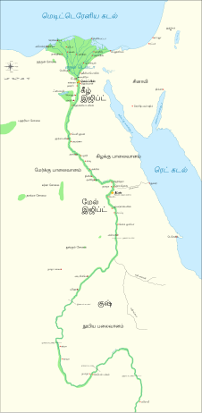
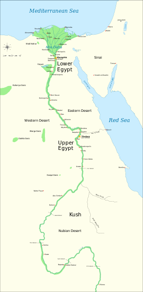
Català: Mapa de l'antic Egipte, que mostra el Nil fins a la cinquena cataracta, i les principals ciutats i llocs del període dinàstic (c. 3150 aC a 30 aC). El Caire i Jerusalem es mostren com a ciutats de referència.
English: Map of Ancient Egypt, showing the Nile up to the fifth cataract, and major cities and sites of the Dynastic period (c. 3150 BC to 30 BC). Cairo and Jerusalem are shown as reference cities.
Date
Source

Own work using:

  • Shaw, Ian , ed. (ई सं २००३) The Oxford History of Ancient Egypt, Oxford University Press ISBN: 0-19-280293-3.
  • Dr. Peter Der Manuelian , ed. (ई सं १९९८) Egypt: The World of the Pharaohs, Bonner Straße, Köln (Deutschland): Könemann Verlagsgesellschaft mbH ISBN: 3-89508-913-3.
  • Digital Egypt - maps. Retrieved on 2007-11-25.
  • NASA PIA04957. Retrieved on 2007-11-25.
  • NASA PIA02647. Retrieved on 2007-11-25.
  • NASA PIA04965. Retrieved on 2007-11-25.

Coordinates:

Image renamed from File:Ancient Egypt map.svg (see #Original upload log).
Author Jeff Dahl
Other versions
Other related versions:[सम्पादन]
Translate this file This SVG file contains embedded text that can be translated into your language, using any capable SVG editor, text editor or the SVG Translate tool. For more information see: About translating SVG files.
This file is translated using SVG <switch> elements. All translations are stored in the same file! Learn more.

For most Wikipedia projects, you can embed the file normally (without a lang parameter). The Wikipedia will use its language if the SVG file supports that language. For example, the German Wikipedia will use German if the SVG file has German. To embed this file in a particular language use the lang parameter with the appropriate language code, e.g. [[File:Ancient Egypt map-en.svg|lang=en]] for the English version. Do not specify a lang parameter if it is not needed. The parameter may prevent the use of a subsequent translation.

To translate the text into your language, you can use the SVG Translate tool. Alternatively, you can download the file to your computer, add your translations using whatever software you're familiar with, and re-upload it with the same name. You will find help in Graphics Lab if you're not sure how to do this.

Licensing

I, the copyright holder of this work, hereby publish it under the following licenses:
GNU head Permission is granted to copy, distribute and/or modify this document under the terms of the GNU Free Documentation License, Version 1.2 or any later version published by the Free Software Foundation; with no Invariant Sections, no Front-Cover Texts, and no Back-Cover Texts. A copy of the license is included in the section entitled GNU Free Documentation License.
w:en:Creative Commons
attribution share alike
This file is licensed under the Creative Commons Attribution-Share Alike 4.0 International, 3.0 Unported, 2.5 Generic, 2.0 Generic and 1.0 Generic license.
You are free:
  • to share – to copy, distribute and transmit the work
  • to remix – to adapt the work
Under the following conditions:
  • attribution – You must give appropriate credit, provide a link to the license, and indicate if changes were made. You may do so in any reasonable manner, but not in any way that suggests the licensor endorses you or your use.
  • share alike – If you remix, transform, or build upon the material, you must distribute your contributions under the same or compatible license as the original.
You may select the license of your choice.

Original upload log

The original description page is/was here. All following user names refer to Commons.

  • 2009-01-29 13:21 Bibi Saint-Pol 1577×3219×0 (412000 bytes) (remove wrong text, adjust frame)
  • 2009-01-29 12:47 Bibi Saint-Pol 1577×3219×0 (413000 bytes) (added frame)
  • 2009-01-29 12:35 Bibi Saint-Pol 1577×3219×0 (412000 bytes) (harmonize colors with the standards + replace unsupported Arial fonts by DejaVu )
  • 2008-02-11 06:55 Jeff Dahl 1577×3219×0 (391000 bytes) (sp fx)
  • 2007-11-29 02:09 Jeff Dahl 1577×3219×0 (391000 bytes) (Rotate Mediterranean Sea label)
  • 2007-11-27 23:32 Jeff Dahl 1577×3219×0 (391000 bytes) (Minor adjustments to Naukratis and Buto)
  • 2007-11-27 18:59 Jeff Dahl 1577×3219×0 (391000 bytes) (Cairo and Jerusalem now with black dots/italics)
  • 2007-11-23 00:04 Jeff Dahl 1577×3219×0 (391000 bytes) (fx scalebar)
  • 2007-11-22 23:56 Jeff Dahl 1577×3219×0 (391000 bytes) ({{Information |Description=A map of ancient Egypt, made with Inkscape |Source=self-made |Date=11-22-07 |Author= Jeff Dahl |Permission= |other_versions={{DerivativeVersions|Ancient Egypt map-ru.svg}} }} )

Captions

Add a one-line explanation of what this file represents
Ancient Egypt (c. 3150 BC to 30 BCE).

Items portrayed in this file

depicts English

copyrighted English

inception English

२२ नोभेम्बर 2007

MIME type English

image/svg+xml

checksum English

955c156a96b2d10b85ced835ac6c60ee2253122d

determination method English: SHA-1 English

data size English

६४१,२६६ byte

height English

३,२१९ pixel

width English

१,५७७ pixel

File history

Click on a date/time to view the file as it appeared at that time.

Date/TimeThumbnailDimensionsछ्य्‌लामिComment
current०३:३९, २० अक्टोबर २०२३Thumbnail for version as of ०३:३९, २० अक्टोबर २०२३१,५७७ × ३,२१९ (६८७ KB)Haziq FaruqiFile uploaded using svgtranslate tool (https://svgtranslate.toolforge.org/). Added translation for ms.
२३:५६, १७ मार्च २०२२Thumbnail for version as of २३:५६, १७ मार्च २०२२१,५७७ × ३,२१९ (६२६ KB)ManlleusFile uploaded using svgtranslate tool (https://svgtranslate.toolforge.org/). Added translation for ca.
१५:२३, ६ मार्च २०२२Thumbnail for version as of १५:२३, ६ मार्च २०२२१,५७७ × ३,२१९ (५६४ KB)ScratchingheadFile uploaded using svgtranslate tool (https://svgtranslate.toolforge.org/). Added translation for ta.
०६:०३, २५ फेब्रुवरी २०२२Thumbnail for version as of ०६:०३, २५ फेब्रुवरी २०२२१,५७७ × ३,२१९ (५६४ KB)ScratchingheadFile uploaded using svgtranslate tool (https://svgtranslate.toolforge.org/). Added translation for ta.
१९:२९, ६ मार्च २०२०Thumbnail for version as of १९:२९, ६ मार्च २०२०१,५७७ × ३,२१९ (५०१ KB)Nilesh shuklaFile uploaded using svgtranslate tool (https://tools.wmflabs.org/svgtranslate/). Added translation for hi.
११:२८, २० फेब्रुवरी २००९Thumbnail for version as of ११:२८, २० फेब्रुवरी २००९१,५७७ × ३,२१९ (४१३ KB)Bibi Saint-Polfix translation mistake on the windrose
१२:१३, ३० ज्यानुवरी २००९Thumbnail for version as of १२:१३, ३० ज्यानुवरी २००९१,५७७ × ३,२१९ (४१३ KB)Bibi Saint-Polfix position of Nile Delta
१२:२१, २९ ज्यानुवरी २००९Thumbnail for version as of १२:२१, २९ ज्यानुवरी २००९१,५७७ × ३,२१९ (४१२ KB)Bibi Saint-Polremove wrong text, adjust frame
१२:०५, २९ ज्यानुवरी २००९Thumbnail for version as of १२:०५, २९ ज्यानुवरी २००९१,५७७ × ३,२१९ (४१३ KB)Bibi Saint-Pol{{Assessments|1=Ancient Egypt map.svg|enwiki=1}} __NOTOC__ == {{int:filedesc}} == {{inkscape}} {{Information |Description= {{en|Map of Ancient Egypt, showing the Nile up to the fifth cataract, and major cities and sites of the Dynastic period (c. 3150 BC

The following page uses this file:

Global file usage

The following other wikis use this file:

View more global usage of this file.

Metadata