
किपा:VietnamChampa1.gif

Size of this preview: ३६१ × ६०० pixels. Other resolutions: १४४ × २४० pixels | ४२५ × ७०६ pixels.
Original file (४२५ × ७०६ pixels, file size: २७ KB, MIME type: image/gif)

|
This historical map image could be re-created using vector graphics as an SVG file. This has several advantages; see Commons:Media for cleanup for more information. If an SVG form of this image is available, please upload it and afterwards replace this template with
{{vector version available|new image name}}.
It is recommended to name the SVG file “VietnamChampa1.svg”—then the template Vector version available (or Vva) does not need the new image name parameter. |
| Description |
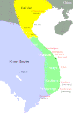
English: Southeast Asia circa 1100 C.E. showing the approximate areas of control for the Dai-Viet (Vietnam), Champa, and Khmer Empires. Note: Control of the regions away from the coast of Vietnam was more nominal than real except along the Red River.
Dai VietChampa Khmer |
||||||||
| Source |
|
||||||||
| Author | Created by CGlassey, based on maps found in DK Atlas of World History and the Times Atlas of World History. | ||||||||
| Permission (Reusing this file) |
I, the copyright holder of this work, hereby publish it under the following licenses:
This file is licensed under the Creative Commons Attribution 2.5 Generic license.
You may select the license of your choice. |
||||||||
| Other versions |
|


File history
Click on a date/time to view the file as it appeared at that time.
| Date/Time | Thumbnail | Dimensions | छ्य्लामि | Comment | |
|---|---|---|---|---|---|
| current | ०४:५८, ५ जुलाई २०२० | | ४२५ × ७०६ (२७ KB) | Sgnpkd | Updates on sites |
| २१:३८, २० ज्यानुवरी २००९ |  | ४२५ × ६६६ (८ KB) | Gryffindor | {{Information |Description= |Source=Own work by uploader |Date= |Author=Gryffindor |Permission= |other_versions= }} | |
| २१:१५, २० ज्यानुवरी २००९ |  | ४२५ × ६६६ (९ KB) | Gryffindor | {{Information |Description= |Source=Own work by uploader |Date= |Author=Gryffindor |Permission= |other_versions= }} | |
| २१:३१, ७ डिसेम्बर २००६ |  | ४२५ × ६६६ (९ KB) | Electionworld | {{ew|en|Cglassey}} South East Asia circa 1100 C.E. showing the approximate areas of control for the Dai-Viet (Vietnam), Champa, and Khmer Empires. Note: Control of the regions away from the coast of Vietnam was more nominal than real except along the Red |
File usage
The following page uses this file:
Global file usage
The following other wikis use this file:
- Usage on ace.wikipedia.org
- Usage on ar.wikipedia.org
- Usage on azb.wikipedia.org
- Usage on bn.wikipedia.org
- Usage on ceb.wikipedia.org
- Usage on ce.wikipedia.org
- Usage on cs.wikipedia.org
- Usage on da.wikipedia.org
- Usage on en.wikipedia.org
- Usage on eo.wikipedia.org
- Usage on fa.wikipedia.org
- Usage on fi.wikipedia.org
- Usage on fi.wikibooks.org
- Usage on fr.wikipedia.org
- Usage on he.wikipedia.org
- Usage on hi.wikipedia.org
- Usage on hu.wikipedia.org
- Usage on id.wikipedia.org
- Usage on io.wikipedia.org
- Usage on it.wikipedia.org
- Usage on ja.wikipedia.org
- Usage on km.wikipedia.org
- Usage on ko.wikipedia.org
- Usage on lt.wikipedia.org
- Usage on min.wikipedia.org
- Usage on ml.wikipedia.org
- Usage on ms.wikipedia.org
- Usage on nl.wikipedia.org
- Usage on no.wikipedia.org
- Usage on pt.wikipedia.org
View more global usage of this file.