
किपा:Non-Native-American-Nations-Territorial-Claims-over-NAFTA-countries-1750-2008.gif
Size of this preview: ५३६ × ६०० pixels. Other resolutions: २१४ × २४० pixels | ४२९ × ४८० pixels | ६७० × ७५० pixels.
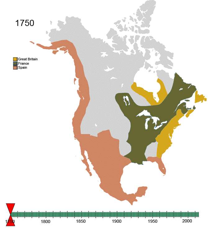
Original file (६७० × ७५० pixels, file size: ७४१ KB, MIME type: image/gif, looped, ९७ frames, १ min ५६ s)
For notes on the individual border changes see Territorial evolution of North America. To make your own animated image use the slides below:
| France | |||
| Present day Canada | |||
|---|---|---|---|
| Canada | |||
| Dominion of Newfoundland | |||
| France | |||
| Britain | |||
| Present day USA | |||
| United States of America | |||
| California Republic | |||
| Confederate States of America | |||
| France | |||
| Republic of Indian Stream | No flag | ||
| Republic of Texas | |||
| Republic of Vermont | |||
| Republic of West Florida | |||
| Russia | |||
| Spain | |||
| Britain | |||
| Present day Mexico | |||
| Federal Republic of Central America | |||
| Mexico | |||
| Spain | |||
| Republic of the Rio Grande | |||
| Yucatán | |||
Images


See Also
-
 |North America
 -
 |Central America
 -
 |Balkans
 -
 |South America
 -

-

-


Summary
| Description | Non-Native-American Nation's Control over North America circa 1750-2008 | ||
| Date | Created March, 2008 | ||
| Source | Own work | ||
| Author | Esemono | ||
| Permission (Reusing this file) |
|
File history
Click on a date/time to view the file as it appeared at that time.
| Date/Time | Thumbnail | Dimensions | छ्य्लामि | Comment | |
|---|---|---|---|---|---|
| current | १४:३२, २१ ज्यानुवरी २०१० | | ६७० × ७५० (७४१ KB) | Esemono | See talk page |
| १६:१४, १९ ज्यानुवरी २०१० |  | ७०० × ७८३ (५३७ KB) | Maps & Lucy | Correct version by same uploader which also exists as a different file. The Spanish explored but did not CLAIM the Pacific coast all the way up to the Russians. Do not revert! | |
| १३:२८, १७ ज्यानुवरी २०१० |  | ६७० × ७५० (७४१ KB) | Esemono | Fix mexico | |
| १२:०५, १२ ज्यानुवरी २०१० |  | ६७० × ७५० (७३१ KB) | Esemono | Reverted to version as of 23:46, 3 January 2010 | |
| ०१:२३, १२ ज्यानुवरी २०१० |  | ६७० × ७५० (६५१ KB) | Maps & Lucy | Fixing map to make thumbnail version display | |
| १५:४९, ११ ज्यानुवरी २०१० |  | ६७० × ७५० (६५१ KB) | Maps & Lucy | Reverted back to accurate image. The Spanish did not CONTROL the north Pacific strip, they just explored it and that does not count | |
| २३:४६, ३ ज्यानुवरी २०१० |  | ६७० × ७५० (७३१ KB) | Esemono | Change Spanish control on the Pacific | |
| ०७:४५, १ ज्यानुवरी २०१० |  | ६७० × ७५० (६५१ KB) | Esemono | Fix NWT island and UK Great Britian | |
| ०१:३२, १ ज्यानुवरी २०१० |  | ६७० × ७५० (६५१ KB) | Esemono | Add pig war, and Rio Rico | |
| १३:१५, ३ डिसेम्बर २००९ |  | ६७० × ७५० (५४६ KB) | Esemono | timeline |
File usage
The following page uses this file:
Global file usage
The following other wikis use this file:
- Usage on af.wikipedia.org
- Usage on anp.wikipedia.org
- Usage on ast.wikipedia.org
- Usage on azb.wikipedia.org
- Usage on az.wikipedia.org
- Usage on be.wikipedia.org
- Usage on bg.wikipedia.org
- Usage on ca.wikipedia.org
- Usage on ce.wikipedia.org
- Usage on cs.wikipedia.org
- Usage on da.wikipedia.org
- Usage on de.wikipedia.org
- Usage on el.wikipedia.org
- Usage on en.wikipedia.org
- History of the Americas
- First Nations in Canada
- List of conflicts in North America
- Talk:History of the Northwest Territories
- List of land borders with dates of establishment
- User:Esemono/NorthAmerica
- Territorial evolution of North America since 1763
- User:Kazkaskazkasako/Books/History
- Wikipedia:Village pump (technical)/Archive 110
- List of conflicts in Mexico
- User:SomeGuyWhoRandomlyEdits/List of conflicts in Mexico
- Usage on en.wikiquote.org
- Usage on es.wikipedia.org
- Usage on fa.wikipedia.org
- Usage on fiu-vro.wikipedia.org
- Usage on fr.wikipedia.org
- Usage on gan.wikipedia.org
- Usage on gl.wikipedia.org
- Usage on hi.wikipedia.org
- Usage on hr.wikipedia.org
- Usage on hu.wikipedia.org
- Usage on hy.wikipedia.org
- Usage on id.wikipedia.org
- Usage on ja.wikipedia.org
- Usage on ka.wikipedia.org
View more global usage of this file.