
किपा:LocationComoros.png
No higher resolution available.
LocationComoros.png (२५० × ११९ pixels, file size: ५ KB, MIME type: image/png)
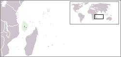
Locator map for the Comoros.
Originally created for English Wikipedia by Vardion.
| |
This work has been released into the public domain by its author, Vardion, at the English विकिपिडिया project. This applies worldwide. In case this is not legally possible: |

|
File:LocationComoros.svg is a vector version of this file. It should be used in place of this PNG file when not inferior.
File:LocationComoros.png → File:LocationComoros.svg
For more information, see Help:SVG. |
 |
File history
Click on a date/time to view the file as it appeared at that time.
| Date/Time | Thumbnail | Dimensions | छ्य्लामि | Comment | |
|---|---|---|---|---|---|
| current | १४:२२, ५ मार्च २००८ | | २५० × ११९ (५ KB) | Panos84 | Location of the island nation of Comoros and its exclusive economic zone. |
| २३:००, ११ डिसेम्बर २००४ |  | २५० × ११५ (६ KB) | EugeneZelenko | Location map for the Comoros.<br/>Originally created for English Wikipedia by Vardion.<br/>{{PD}}<br/>Category:Country locator maps |
File usage
The following page uses this file:
Global file usage
The following other wikis use this file:
- Usage on ar.wikipedia.org
- Usage on bg.wikipedia.org
- Usage on bpy.wikipedia.org
- Usage on bs.wikipedia.org
- Usage on ceb.wikipedia.org
- Usage on de.wikinews.org
- Usage on de.wiktionary.org
- Usage on en.wikipedia.org
- Usage on en.wikivoyage.org
- Usage on en.wiktionary.org
- Usage on eo.wikipedia.org
- Usage on es.wikipedia.org
- Usage on eu.wiktionary.org
- Usage on frp.wikipedia.org
- Usage on fr.wikipedia.org
- Usage on fr.wiktionary.org
- Usage on he.wikivoyage.org
- Usage on hif.wikipedia.org
- Usage on hr.wiktionary.org
- Usage on hu.wikipedia.org
View more global usage of this file.